


co grang fond

sameja
User
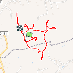

Length
4.2 km

Max alt
89 m

Uphill gradient
105 m
Km-Effort
5.6 km

Min alt
48 m

Downhill gradient
111 m
Boucle
Yes
Creation date :
2019-01-15 13:05:28.003
Updated on :
2019-01-15 13:05:28.003
57m
Difficulty : Unknown

FREE GPS app for hiking
 SityTrail
IGN / Geographical institutes
SityTrail Plus
The world is yours!
About
Trail Other activity of 4.2 km to be discovered at Guadeloupe, Unknown, Le Moule. This trail is proposed by sameja.
Positioning
Country:
France
Region :
Guadeloupe
Department/Province :
Unknown
Municipality :
Le Moule
Location:
Unknown
Start:(Dec)
Start:(UTM)
669572 ; 1801073 (20Q) N.
Comments